If you're wanting help with Site Surveys then contact us...
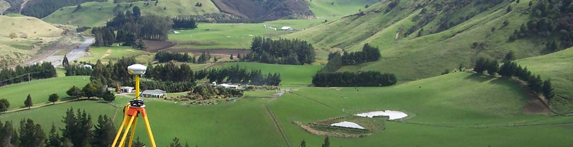
Topographical and site surveys involve the collection of detailed data about the land's features, providing essential information for planning, design, and development purposes. These surveys map terrain contours, existing structures, vegetation, and utilities, offering a comprehensive understanding of the site. This data helps inform effective design strategies and ensures the feasibility of development plans.
In recent years, 3D ground models have become increasingly important, particularly for architects in house design. Topographical surveys are also often required by local authority building control departments to ensure certainty regarding the relationship between proposed buildings and property boundaries. By providing a clear representation of the land's topography, these surveys and models help prevent issues during construction and ensure compliance with planning and zoning requirements.
Boundary Survey / Boundary Marking: Boundary surveys are conducted to accurately determine the legal boundaries of a property. These surveys are essential for resolving boundary disputes, positioning new fences, and providing clarity on property limits for development or construction. Surveyors use a combination of historical records, existing marks, and precise measurements to establish the correct boundary lines.
As-Built Surveys: We document the exact locations and dimensions of constructed features, verifying compliance with design plans. These surveys provide an accurate record of the completed project, essential for future maintenance, renovations, or legal documentation, ensuring that what is constructed matches the intended design.
Height in Relation to Boundary (HIRB): Council regulations define maximum height planes to control how high a building can be in relation to its boundary, helping to prevent overshadowing and privacy issues between neighbouring properties. HIRB surveys measure the building height and setback from the boundary, comparing these measurements to the boundary elevations to ensure compliance with local council rules.
Setout & Siting Certifications: Our team provides setout and siting certifications, ensuring that structures are positioned correctly on-site according to approved plans. This service is crucial for aligning construction with design intentions, preventing costly errors that may arise from assumptions, such as relying on fences to be the boundary when, in many cases, they are not accurately placed. Setout and siting certifications ensure that buildings, foundations, and other structures are correctly located within their allotted spaces, avoiding potential conflicts with property boundaries and local planning regulations.
Cadastral Survey: We conduct cadastral surveys to define property boundaries accurately for legal transactions. Our surveys support property sales, purchases, and subdivisions by providing precise boundary delineations and ensuring that all legal requirements are met, facilitating smooth property transfers.
Aerial and Drone Surveying: Utilising advanced drone technology, we capture high-resolution aerial data for efficient and accurate mapping. This method allows for rapid data collection over large areas, producing detailed orthophotos and 3D models that support planning, design, and monitoring activities. Aerial and drone surveys are particularly useful for quantifying volumes such as stockpiles or earthworks and mapping extensive areas quickly providing 3D models and up to date georeferenced aerial photos.
Removal of Limitations Survey: Particularly common in older and undeveloped areas, some Records of Title are limited, meaning the boundaries and dimensions of your property are not guaranteed. This can become an issue when there is a boundary dispute or when designing new buildings, as the structure cannot be accurately positioned in relation to the boundary, potentially causing problems with setback and height compliance. A removal of limitations survey is one of the most complex types of surveys and often requires extensive investigation of the property's historical records to gather enough evidence to define the boundaries and remove the limitations from the Record of Title. By removing these limitations, the marketability and development potential of the land are enhanced, providing property owners with clear, definitive title information.
Easement and Covenant Surveys: Easements and covenants are essential legal instruments that define property rights and land use restrictions. We survey and document easements for rights such as access (Right of Way), drainage (Right to drain water and sewage), and utilities (Right to convey water, electricity, and telecommunications). These easements ensure service connections and access rights are legally secured for property owners.
Covenants are commonly used to protect areas of significant natural landscape, habitat, or archaeological and cultural sites. They also define restrictions such as height limitations or no-build zones to preserve views and maintain the character of a development. Our team provides precise surveying and documentation to ensure easements and covenants are correctly established, registered, and compliant with regulatory requirements.
Rentable Area Surveys / BOMA: We measure rentable areas in compliance with BOMA standards, providing accurate data for leasing and valuation purposes. Our measurements ensure that both landlords and tenants have a clear understanding of the space being leased, promoting fair rental agreements and informed financial decisions.
Monitoring Surveys: Monitoring surveys are primarily used to detect land instability and/or structural movements over time, ensuring the safety and integrity of buildings and infrastructure. By regularly measuring and analysing positional changes, we identify potential issues early, allowing for proactive maintenance and risk mitigation, safeguarding both property and occupants.
Laser Scanning: Laser scanning is a highly accurate and efficient method used to capture detailed 3D data of a physical environment. This technology uses laser beams to scan surfaces and objects, creating a precise digital representation of the scanned area. The resulting data, known as a point cloud, provides a highly detailed, three-dimensional map that can be used for a variety of purposes, such as design, as built, and infrastructure monitoring.
Laser scanning is particularly useful for complex or large-scale projects where traditional survey methods might be time-consuming or impractical. It can quickly capture detailed information in difficult-to-reach areas, reducing the need for physical access and minimizing the potential for human error. The high level of accuracy and speed makes laser scanning ideal for applications like as-built surveys, heritage preservation, Unit titles, BOMA, and monitoring.